Unlike other well-known monuments of southern Kazakhstan, whose discovery and study are associated with the names of researchers of the 19th century or archaeologists of the Soviet era, the petroglyphs of Kulzhabasy remained unnoticed almost to the present day. The circumstances of the discovery of this remarkable monument are quite unusual for the modern practice of petroglyph research and require a special explanation.
As is well known, all the principal petroglyph sites of southern Kazakhstan and Central Asia were discovered by archaeologists after receiving information about their existence from the local population, geologists, naturalists or, at best, as a result of more or less purposeful field searches. Thus, more than a century ago Ch. Valikhanov and N. N. Pantusov were given information about Bayanzhurek, and N. G. Khludov about Saimaly-Tash; in the 1950s-60s the existence of Tamgaly, Koybagar and Arpauzen became known respectively to A. G. Maximova and M. K. Kadyrbaev, and A. N. Maryashev, and in the 1980s A. N. Maryashev and A. E. Rogozhinsky were informed about Yeshkiolmes, this largest monument of Kazakhstan.
In 1961 the entomologist and local historian P. I. Marikovsky reported a small number of unremarkable drawings in the Kulzhabasy Mountains (Marikovsky, 1961), having in fact only briefly surveyed the western end of the ridge; this report did nothing to promote further study of the monument in the following years. The discovery of Kulzhabasy as a major petroglyph site and archaeological complex took place only forty years later.
 In 2000-2001, in the course of the INTAS 97-2220 project devoted to the study of the transitional stage from the Bronze Age to the Early Iron Age in three different landscape zones of Semirechye — the dry steppes of the Chu-Ili Mountains, the foothills of the Dzungarian Ridge and the high-mountain plateaus of the Trans-Ili Alatau — a multidisciplinary geo-archaeological approach was used to understand the pattern of distribution of monuments (including petroglyphs) across different ecological habitats. This approach was aimed at identifying the regularities in the geographical distribution of the developed lands, habitats and monuments of the region in connection with climatic changes and shifts in cultural stages. The presence in Semirechye of a huge number of petroglyphs dating from the Bronze Age to the ethnographic period makes it possible to use here, as a component of scientific research, the study of rock engravings as an important indicator of the cultural development of the landscape.
Research at several polygons of Semirechye showed, firstly, that livestock breeding (pastoralism) was the principal economic occupation in the semi-deserts, foothills and mountain valleys from the Bronze Age to the ethnographic period. And, secondly, that the pastoral use of natural resources was carried out through the annual exploitation of two or more surrounding environments (areas) in connection with seasonal migrations and the “multi-home” residence of the population. At the same time there were favored ecological areas where summer and winter pastures were located quite close to each other, within a few hours’ walk; most probably, such areas represent the earliest habitation sites of the herdsmen.
The simplest case is represented by valleys where, under favorable climatic conditions and a limited population, the summer and winter pastures can be formed respectively by the northern and southern slopes. Such ecological complexes are concentrated in mountain valleys, foothills, desert oases and river canyons. In these places dwellings are located on the summer and winter pastures, near water sources on terraces sheltered from the north-eastern winds; the burial grounds are on the hilltops or on positive relief forms (alluvial fans). Besides settlements and cemeteries, the process of the culturation of the landscape is attested by the remains of pyramids of rough stones (obas), enclosures, stelae, cup marks and petroglyphs, wherever there is good rock material.
Without exaggeration it can be said that in Semirechye petroglyphs are found everywhere where the human habitat coincided with suitable rock material. Good rock material, i.e. surfaces possessing certain specific characteristics, such as smoothness, a patina gleaming like metal, suitable dimensions, attractive natural inclusions or surface defects, is not present everywhere. It does not occur in the Tien Shan and Dzungarian mountains, where tectonic faults have raised giant granite blocks of volcanic origin. It is represented in a strip 50-100 km away from the northern foothills of the Tien Shan, where tectonic movements have damaged only the flat sedimentary plains and exposed metamorphic rocks of sandstone and shale, which are the favorite material for executing petroglyphs. In southern Kazakhstan such material is represented by a strip stretching from the Karatau Mountains in the west towards the Chu-Ili Mountains and the north-western spurs of the Dzungarian Ridge in the east.
At the intersection of this well-defined geological zone and the natural human habitat discussed above lie the principal petroglyph sites of southern Kazakhstan (Fig. 15). The sites of Arpauzen and Koybagar in the Karatau Mountains are located in the foothills with a winter pasture (800 m above sea level) and a summer pasture a few hours’ ride away on the Bessaz plateau (“five meadows”) at an altitude of 1700 m above sea level. In Semirechye several valleys stand out that are endowed with such favorable ecological conditions, where summer and winter pastures are located respectively on the northern and southern slopes. Among those surveyed in 2000-2001 are, for example, the foothill valleys of the upper reaches of the Bien River (the petroglyph sites of Bayanzhurek and Tasbas) and of the Koksu River (Yeshkiolmes) in the Dzungarian Alatau, and the semi-desert valley of the upper reaches of the Kopa River between the Kendyktas plateau (1500 m) in the south, with its rich summer pastures, and the Kulzhabasy Ridge (1183 m) in the north, where the valleys provide winter shelters.
The study of these human habitats, determined primarily by ecological considerations, led to the discovery at each polygon of dozens of previously unknown petroglyph sites. Most of them are of small and medium size and of medium-quality petroglyphs, but in a number of cases monuments of paramount importance were discovered. The Kulzhabasy site in the south-western spurs of the Chu-Ili Mountains belongs precisely to this category: in the number and antiquity of its petroglyphs, the quality of their execution, and the expressiveness and originality of its images, it ranks among the most important monuments of Kazakhstan, along with Tamgaly, Yeshkiolmes and Bayanzhurek in Semirechye and Arpauzen in the Karatau Mountains.
Thus, the Kulzhabasy complex was discovered and surveyed by R. Sala and J.-M. Deom only in 2001, as a result of geo-archaeological observations and analysis which drew our attention to this area. This “belated” discovery of a monument located relatively close to modern transport routes can be explained by the weak economic use of the area at the present time; it suggests the possible existence of other similar monuments in territories that were once densely populated and are now desert.
In the summer of 2002 the Kulzhabasy site became for the first time the object of special research devoted to the study of monuments of the Bronze and Early Iron Ages and the documentation of petroglyphs. The excavations of the archaeological monuments were carried out under the direction of A. N. Maryashev (Institute of Archaeology of the National Academy of Sciences of the Republic of Kazakhstan), while the geo-archaeological survey (with the participation of B. Zh. Aubekerov) and the documentation of the complex were carried out by R. Sala and J.-M. Deom within the framework of the above-mentioned INTAS project. As a result of this work, the Bronze Age burial ground of Kulzhabasy III, belonging to the Late Alakul type of monuments, was partially excavated; monuments of this type were previously known in Semirechye from excavations at the Oi-Dzhailyau tract (Kendyktas Mountains) and date to the 14th-12th centuries BC (Maryashev, Goryachev, 1992, p. 9). A preliminary geo-archaeological survey of the complex made it possible to determine the main geographical features of the area, to identify a large number of monuments from different periods, and to begin creating special GIS-format maps of the territory.
Scientific research at Kulzhabasy continued in 2003 and improved considerably as a result of the cooperation of two research teams: the work of the INTAS 2000-0699 project team (R. Sala, B. Zh. Aubekerov, J.-M. Deom) was devoted to the geo-archaeological study of the use of the territory’s natural resources (soils, water) in different epochs; the work of the NIPI PMK team (A. E. Rogozhinsky) within the framework of this UNESCO project was connected with the archaeological study and documentation of the complex.
In general, the Kulzhabasy complex was investigated as a cultural landscape. First of all, on the basis of the new data obtained, the modern geological, geomorphological, hydrological and ecological features of the area were analyzed; the necessary samples were taken at all the studied natural and archaeological sites for the reconstruction of the paleo-ecological and paleo-climatic conditions. The range of archaeological sources was significantly expanded through the detailed documentation of all traces of cultural activity and impact on the landscape: habitation and burial sites, ceramic finds, water structures, stone structures of the oba type, enclosures, cup-shaped depressions and, finally, petroglyphs. Archaeological excavations were carried out selectively on the basis of the principles of archaeological ethics developed earlier at Tamgaly (minimum destruction of the monument and landscape — maximum scientific information in a comprehensive archaeological and geological study and documentation of the site); thus the Bronze Age settlement of Kulzhabasy V and the burial grounds of Kulzhabasy V and VI were discovered and partially investigated. The documentation of the Kulzhabasy petroglyphs, in addition to the basic methods (recording the locations with GPS, creating indexed panoramas, photographing and copying the panels with petroglyphs), included the identification of the main types of damage threatening the condition of the rock art, as well as the making of casts for the use-wear analysis of various series of images.
The main scientific results of the comprehensive study of the monument consist in determining the boundaries and internal structure of the geo-archaeological complex, as well as in determining the place of the petroglyphs in the cultural context.
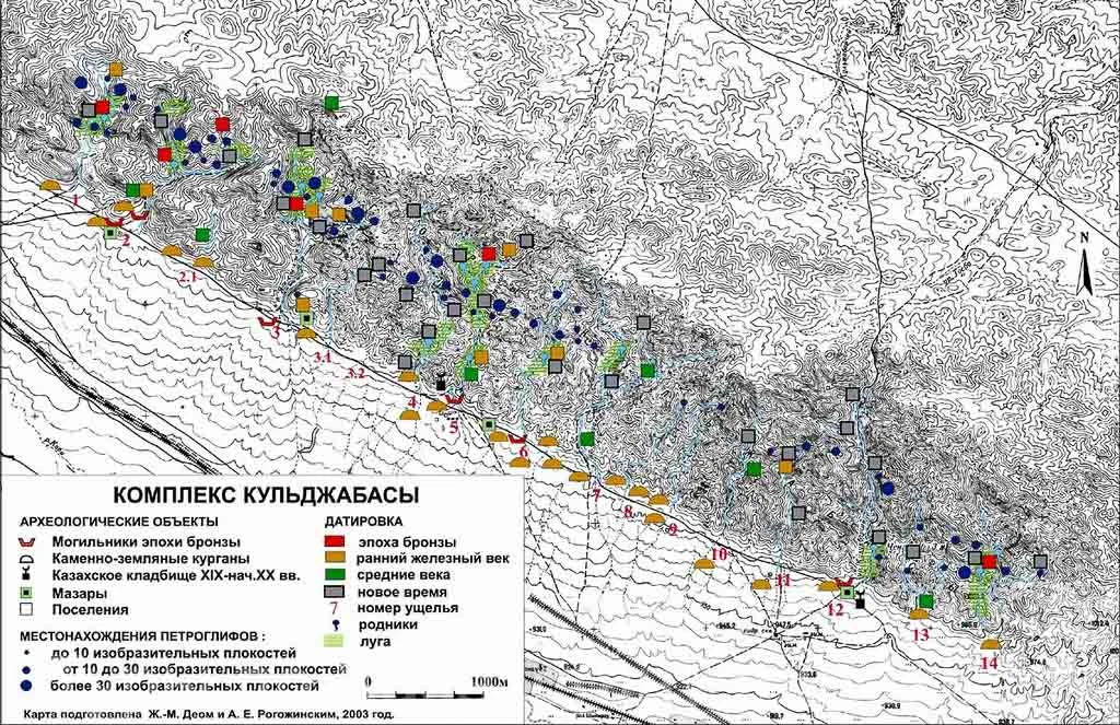
The most important scientific and practical result of the work carried out in 2003 is the identification of the Kulzhabasy archaeological complex (Fig. 16), which is necessary to substantiate the boundaries of its protection zone and its inclusion, along with Tamgaly, Yeshkiolmes and Arpauzen, in the List of Monuments of Republican Significance and the Provisional List of World Heritage Monuments of UNESCO. Further study of this remarkable monument should develop within the framework of an integrated solution to the tasks of its preservation and use.
(B. Zh. Aubekerov, R. Sala)
Geography and geomorphology. The Kulzhabasy Ridge forms the center of the southern end of the Chu-Ili Mountains and is located between the Kendyktas plateau and mountains in the south-west, the Khantau Mountains in the north-west, and the Anrakhai Mountains in the north and north-east. The Kulzhabasy Mountains are the watershed of three drainage areas: the Kopa River in the east, the Chokpar and Shingeldy rivers in the west, and the Kopalysai in the north-east.
The climate of the area is classified as sub-Mediterranean semi-arid continental: the mean annual temperature is +7.6° (January -5.9°, July 25.1°), the precipitation level is 400 mm (8-18 mm in the July-August period), the continentality index is 31, and the summer aridity index is 10-17. The landscape belongs to the foothill deserts and semi-deserts; the soils are predominantly northern sierozem (aridisol). Some areas near the springs are characterized by chestnut soils, on which meadow vegetation and trees (willow) have developed. Several species of animals live here: mountain sheep, deer, wolves, foxes, wild cats, ground squirrels, hedgehogs, birds of prey and migratory birds, snakes and desert insects.
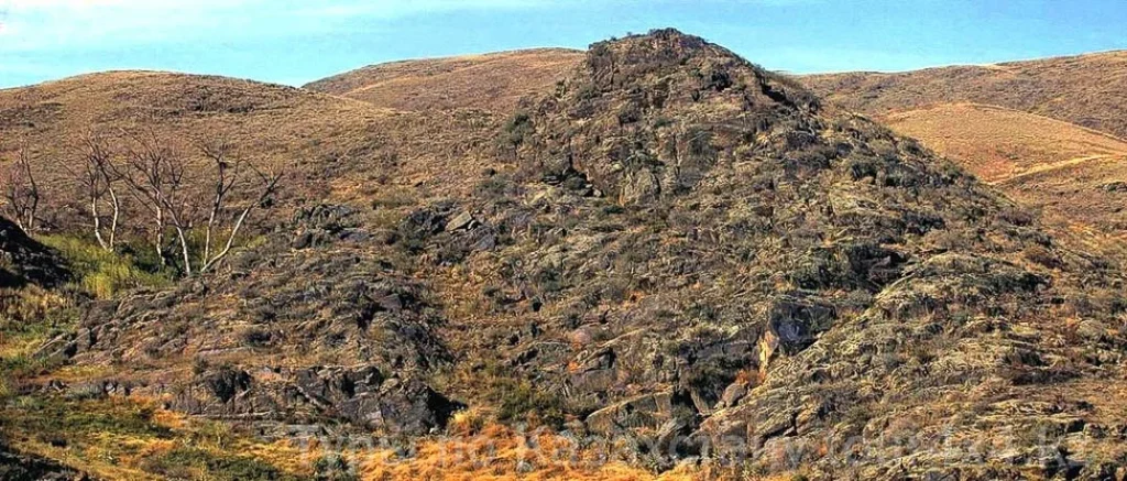
The name of the mountains, “Kulzhabasy”, translated from the Kazakh language means “the crest of a sheep’s spine”, as the mountain chain resembles the protruding spine of a giant animal skeleton. It is a tectonically uplifted block which, north of the fault, crosses an ancient anticlinal structure whose erosional dissection has formed the relief of the Kulzhabasy Mountains, which extend up to 40 km in a NW-SE direction and reach 1183 m above sea level in the west, with a relative height of up to 180 m.
The northern part of the mountains is an extensive dry plateau; the southern slopes are cut by several parallel erosional valleys, some of which are up to 2-3 km long. The ridge is divided by a depression into an eastern part and a western, higher one, endowed with a larger number of springs and better rock material.
The chain of mountains begins in the west with the small Kostobe ridge, about 7 km long. Its southern slopes are cut by 3 valleys provided with springs, with black rock surfaces of poor quality bearing petroglyphs of minor importance, which together form the western periphery of the main complex. Most probably, it was the petroglyphs of the Kostobe 3 gorge that P. I. Marikovsky saw.
The mountains continue eastward with the ridge called Kulzhabasy, stretching for more than 30 km. On the southern slope of the ridge, over a length of 6 km, the first 5 valleys stand out (the valleys are numbered from west to east and are hereafter denoted briefly: V1, V2, V3, etc.). The highest summits are located in this section, with the greatest abundance of springs, the best patinated rock surfaces and the largest number of petroglyphs of the best quality. It is these valleys that form the center of the Kulzhabasy petroglyph complex. In terms of the number and total area of smooth patinated rocks, two zones of concentration of rock outcrops stand out in particular, associated with two neotectonic faults crossing valleys V1-V6 and V11-14 between the 1090 and 1140 m marks above sea level. Between the two distinguished zones lie valleys V7-11, distinguished by insignificant rock outcrops.
Two types of relief take part in the geomorphological structure of the area: erosional-tectonic low hills and the inclined piedmont plains of the Kopa tectonic depression.
Two large elements stand out on the piedmont plain: the very floor of the Kopa tectonic depression, filled with Neogene-Quaternary terrigenous deposits, and a comparatively narrow strip of proluvial aprons at the point where the valleys emerge onto the plain. In archaeological terms the latter are of exceptional importance, since it is precisely with them that the burial monuments of various epochs are primarily associated.
The erosional-tectonic low hills were formed by the erosional activity of the valleys that cut through the tectonic escarpment. In shape these are ridged-hummocky hills combined with elongated crest-like forms. Toward the valleys the slopes of the hills are comparatively steep, and patinated rock outcrops are often observed on them.
The main massif is composed of shales interbedded with sandstones of the Devonian and Ordovician, and closer to the watershed — with effusive formations. The latter form large planes on which the petroglyphs are located.
The valleys of the Kulzhabasy Mountains have a simple structure. They contain a floodplain and two river terraces. It is on the river terraces that both ancient and later settlements are located. Moreover, the bulk of the settlements are located in the middle part of the valleys. A clear dependence of the size of a settlement on the area of the terraces is observed: large settlements are situated on wide terraces, while single dwellings and small settlements are at the mouths of side tributaries. It is noteworthy that in the settlement zone the floors and slopes of the valleys everywhere bear traces of cultural development (the remains of various structures survive, including dam-weirs and slope filters that hold back the coarse clastic material moving down from the slopes).
The width of the floors of the main valleys ranges from 40-50 to 120-150 meters. The longitudinal profile of the valleys is stepped, which is connected both with the features of the bedrocks, which resist erosion to varying degrees, and with the scarps of neotectonic faults. It is precisely with the fault zones that the active springs are associated.
The properties of the substrate rocks are of great importance for understanding the location of the petroglyph clusters. From the mouths of the gorges almost to the watershed, the principal rocks are shales, sometimes intersected by quartz veins. Sandstone layers within the shale sequence are of subordinate importance (that is, in percentage terms there are more shales than sandstones). The orientation of the structures and layers of the shale-sandstone sequence is close to sub-latitudinal — and it crosses the valleys transversely. Therefore, fairly large clusters of patina-covered rock outcrops are observed on the valley slopes. At the same time, the morphological features of different sections of the valley and the combinations of shales, sandstones and quartz veins in different places create certain regularities in the formation of the rock massifs on the hill slopes. The cleavage, which has 2-4 systems, is also of great importance: the first, principal, sub-latitudinal system is associated with the foliation of the sequence, while the others reflect the features of the extension or compression zones of the rock folds and are, on the whole, oriented from south to north, dipping east and south, or — submeridionally with a dip to the west and south-west. In its parameters, the shale sequence is unfavorable for the formation of particularly large planes, which more often have surfaces of up to 1-2 sq. m.
Of interest is the location of the bulk of the petroglyphs in the middle parts of the gorges, which, in our opinion, is connected with the morphological features of the valleys. Steep slopes with a large number of rock outcrops develop here. The lower and upper sections of the valleys are characterized by a different regime of erosional activity. In the lower parts of the gorges, gently sloping ridged hills are formed, practically devoid of rock outcrops on their slopes, apart from small exposures directly near the channel. In the upper parts of the valleys, where erosional activity is still weakly developed, the slopes are covered with stony talus and scree and also lack a large number of rock outcrops. In the middle parts of the gorges, however, the erosional process proceeds most actively: here the greatest relative elevations occur, and here the rocks are exposed at various levels.
Topography of the valleys and rock formations. Rock blocks of shale frame the southern slopes of the Kulzhabasy Mountains along their entire length, but only along the western part of the ridge are these blocks more numerous and with a better patina. Mountain streams are also concentrated in this same territory, and near them are settlements, burial grounds and traces of pastoral activity of all epochs, which together with the petroglyphs form one of the most picturesque cultural landscapes of all Central Asia.
In the western part of the mountains 14 valleys stand out, the best supplied with water. Here are the highest summits and the best rock groups with patinated shale surfaces. Here, in an area of approximately 10 x 3 km, about 40 groups of petroglyphs identified by us are concentrated, bearing no fewer than 3000 drawings. These valleys (V1-14) form the central location of the petroglyphs. In terms of the number and total area of smooth patinated rocks, two zones of petroglyph concentration stand out in particular, associated with two neotectonic faults crossing valleys V1-V6 and V11-V14. Valley 3 (groups 2, 3, 4) is distinguished by a high density of rocks with petroglyphs of excellent execution. Between the two distinguished zones lie valleys V7-V11, distinguished by poor rock material.
The water springs are associated with the neotectonic faults, and many of them flow all year round. At present, seasonal streams are active along the entire western part of Kulzhabasy; permanent streams are located in V3, V5, V12; very scanty springs are found in the smallest valleys V8, V9, V10, V11. Remains of settlements of the ethnographic and medieval periods have been found in all 14 valleys; in 8 of them, traces of water management (dams, weirs) and agricultural activity have been recorded.
Farther east there is a lowering of the mountain massif (V15-V17), separating the western part of the ridge from the eastern. Valley V16 is the only one where a small river flows throughout the summer; this valley also offers the best road crossing the entire mountain massif transversely. From here and farther east, the combination of water and rock occurs less and less often, just as the number and quality of the engravings decline.
Ecology. The arid climate and the environment of the region make a reasonable, careful use of water and plant resources necessary, even though a mobile way of life is predetermined by the natural habitat of man. From this point of view, the mountain valleys of Kulzhabasy, on the one hand, and the steppe plateau and the Kendyktas Mountains (1500 m above sea level), located 35 km to the south, together form a compact area with additional ecological opportunities. The historical importance of the ecological interconnection of these two areas is confirmed by ethnographic data and by the complete similarity of the archaeological remains discovered in Kulzhabasy and Kendyktas, which belong to all epochs.
The Kendyktas plateau and mountains and the long valleys cutting through them provide a relative abundance of water and amenities for habitation. Thanks to the insignificant snow cover in winter, which makes it possible to maintain the herds through fodder activities and short movements, as well as the rich copper deposits known in the south-western valleys, the Kendyktas area is the economic and demographic center of this region. In Kulzhabasy there is little water and few people, but in any case the mountains provide a certain number of good winter settlements in valleys endowed with water springs, sheltered from the winds and well warmed by the sun, which favors the grazing of livestock on the southern slopes.
However, the rock material in Kendyktas is very poor, and only a few scattered petroglyphs have been discovered there. Kulzhabasy has rock surfaces of the quality necessary for executing petroglyphs of good quality. In addition, the Kulzhabasy Ridge is located at the very center of the intersection of two natural routes: one runs along the Kopa depression from west to east, the other — from south-east to north-west along the line of springs and mini-oases, along the boundary of the deserts of the Chu-Ili ridge. In this respect the Kulzhabasy area is a crossroads of a vast cultural region, and in the course of history it was a “witness” to the migrations of many peoples and tribes. The rocks gleaming with a “metallic” sheen and the favorable conditions for habitation made the Kulzhabasy area (admittedly, today — from the archaeological point of view, but probably also for our most inquisitive ancestors) a revered cultural center of the wider region for more than three thousand years.
The cultural landscape of Kulzhabasy forms a geo-archaeological complex covering an almost rectangular zone of 10 x 3 km, divided into two parts. The first, southern, part, with an area of about 10 x 1 km, includes semi-desert foothills and alluvial fans containing burial monuments of all epochs. The second, northern, part, with an area of 10 x 2 km, includes the mountainous terrain with 14 valleys, water springs, “metallic” rock surfaces and various other types of monuments (settlements, irrigation structures, paths, petroglyphs and cup marks, obas and layouts of rough stone, stone enclosures).
The burial monuments of all epochs are located directly at the mouths of the gorges (some kurgans — on mountain passes); settlements with distinctly pronounced rows of buildings and dwellings are located in the inner parts of the valleys, where the springs associated with the neotectonic fault still flow, and the petroglyphs occupy the slopes of the hills and the watersheds.
Petroglyphs. Throughout the entire history of habitation in the valleys of Kulzhabasy, man was surrounded by rocks with surfaces of good quality. The time came — perhaps it was the Neolithic or Eneolithic, or at least the Early Bronze period (the beginning of the 2nd millennium BC) — and petroglyphs of high quality of execution began to be carved on the best surfaces of all the rocks.
It is possible to make an approximate estimate of the potential offered by the rock material, the total number of engravings and the degree of use of the surfaces for each petroglyph site (group). In the study area a total of 40 rock outcrops with good rock surfaces (smooth, patinated and of sufficient size) have been identified; on each of these rocks there are at least several surfaces with images. In total, no fewer than 3000 expressive drawings have survived on 600 image surfaces.
Eight well-watered valleys with the largest number and the highest quality of rock surfaces stand out: V1 — 2 groups of petroglyphs, V2 — 8, V3 — 4, V4 — , V5 — 4, V6 — 2, V12 — 3 and V14 — with 4 groups. Together they possess 30 groups of petroglyphs, of which 18 are of first-rank importance in execution, quantity, antiquity, scientific content and artistic expressiveness. The highest concentration of petroglyphs is observed on groups 2-4 in V3; the highest degree of use of the available rock material is in V3 and V5. The remaining six valleys contain a total of 10 groups of petroglyphs. At the same time, V7 has very scanty rock material, and V8-11 and 13, each only about 1 km long, are completely dry, with poor rock material, which largely explains the low density of sites or the complete absence of petroglyphs, for example in V10.
Settlements. Ceramic finds and the excavations carried out have shown that the terraces chosen for the early (Bronze Age) settlements remained absolutely uninhabited during all subsequent historical periods. No traces of archaic (pre-Bronze Age) camp sites or burials have been discovered. In the middle and upper parts of the most humid and sheltered valleys V1(?), V2, V3, V5, V14, six sites of Bronze Age ceramics and structures have been identified.
The data relating to the settlements of subsequent epochs testify to a progressively advancing colonization of the territory of the complex. Find spots of ceramics of the Saka-Usun period (14 locations) are situated in the same valleys as the Bronze Age settlements, on neighboring terraces that are similar or drier.
In the medieval period a significant expansion of the use of the territory is observed, as the number of remains of medieval settlements increases to 22. They are located in the same valleys and more widely, occupying suitable sites in the arid valleys of the complex. About 50 sites with structures belong to the ethnographic period, the 19th – first third of the 20th centuries, when the development of the territory of the complex reached its maximum. Thus, V1-3, 5, 12 and 14 always remained the most populated, while V8-11 and 13 were the least inhabited.
Irrigation structures. Four types of structures associated with the use of water have been identified: small ponds, pools, cisterns and stone fences. Ponds and pools have been found in the humid valleys V2-5, 14 and were used to hold water and groundwater within the valley, as well as to fence off the streams. Cisterns have been found mainly in the driest valleys V7-10. Stone fences, stretching continuously along the gorge for several kilometers, have survived in V5 and V10. In the opinion of B. Zh. Aubekerov, they may have been intended to protect the floodplain with its fodder vegetation from the debris descending from the slopes of the gorge. According to the observations available, all these structures belong to the ethnographic period. Indirect evidence of the possible use of these territories is given by the traditional name of V5 — “Karbuzsai” (“watermelon gorge”). Samples from the geological sections are being studied at present and are expected to provide data on earlier agricultural activity.
Burial grounds. The burial monuments are located in the foothills and on the alluvial fans. They include Bronze Age stone enclosures with graves in the form of boxes and box-cists; Saka-Usun and medieval Turkic kurgans, and Kazakh cemeteries and mausoleums.
The largest Bronze Age burial grounds, including 25-30 structures visible on the surface, have been discovered at the mouths of valleys V3 and V5. Although the petroglyphs indicate a very ancient development of the territory, the earliest of the discovered burials date to the Middle and Late Bronze periods. Research will continue, but it cannot be ruled out that the culturation of the landscape with burial monuments began only in the Middle and Late Bronze Age. They are located at the richest valleys like “guards at the gates”, and their historical appearance may point to an early phase of social stratification and land development.
Kurgans are present at the mouth of every valley, forming chains of 3-8 structures; especially large burial grounds, numbering 20-25 kurgans, are located in front of the V2 gorge and the dry valley V8 (!). Their layout principle is completely different from the topography of the Bronze Age graves, which are grouped near the very entrance of the best valleys. The kurgans are arranged in a row, like a projection of the edges of the valleys toward the plain. The poor condition of the stone cover of the kurgans is caused by the intensive removal of stones for the construction needs of the Kazakh burial grounds of the ethnographic period and of farm structures in the Soviet period. Medieval kurgans, a Turkic stele and memorial enclosures are located near V2 and V6. Kazakh clan cemeteries in special low stone enclosures are situated near V2, 3, 5, 6, 12 and occupy the same topographic position as the burial grounds of the Bronze Age; mud-brick domed mausoleums are located near V5 and V12. In the Bronze Age and the Modern period, the most convenient places for making burials were the entrances of valleys V2, 3, 5, 6, 12, which are at the same time 5 of the 8 most humid, most populated and richest in petroglyphs gorges.
Stone obas and stone layouts. Vertical pillars of stones (obas) have been built practically on the summit of every hill and number in the hundreds. From each of them at least 20 others can be seen. The tallest obas reach a height of one to three meters. They more often occur singly on a summit and in exceptional cases in groups of two or four, connected by stone walls. Many of them may be very ancient, and their pristine appearance has completely changed.
Mounds of large stones shaped like kurgans (sometimes probably genuine kurgans) occur singly or in pairs on practically every mountain pass, and in V2 and V3 — on the summits. Often the base of such mounds is formed by an oba.
The abundance of monuments of these types in V12 can be partly explained by the special functions of this longest valley as the best route connecting the plain in the south and the plateau in the north in the western part of Kulzhabasy.
In general, all these monuments today have an additional topological influence on the semiotic landscape. The burial grounds mark the southern entrance of the valleys; the settlements and water structures mark special areas along the base of the valleys; the petroglyphs decorate the rock surfaces that cross the slopes transversely in the middle parts of the valleys. The obas and stone layouts began or completed the process of the culturation of the landscape by totally enclosing the territory of each individual valley.
The relative importance of these various structures changed over the course of history. At the same time, at each stage the traces of the preceding time remained clearly visible, playing the role of a background and an inherited context.
The petroglyphs of Kulzhabasy belong to several historical epochs and date from the archaic period (possibly the Early Bronze Age or the Eneolithic) to the Turkic Middle Ages. The repertoire of the petroglyphs is on the whole typical of Semirechye, but with some reservations concerning the images of the most ancient periods, which makes it possible to single out Kulzhabasy among the other representative monuments of Kazakhstan. In style of execution, series of drawings also stand out, both those possessing local features (for example, the gigantic figures of bulls on horizontal surfaces) and those echoing other monuments of Semirechye (Tamgaly, Khantau, Yeshkiolmes) and of more distant territories of Central Asia, Siberia and Western Mongolia.
The archaic period is represented by engravings of an earlier time than the Bronze Age, which makes it possible to rank Kulzhabasy among the most ancient petroglyph sites in Kazakhstan. The rich repertoire of the petroglyphs of the subsequent periods, with the exception of a few unique images (warriors in wolf masks, mirrors, warriors of the Saka period), is mostly analogous to the repertoire of other monuments of southern Kazakhstan and has much in common with the later monuments of Central Asia, Siberia and Western Mongolia.
The study of stratigraphy, patina, technique and style has made it possible to carry out a chronological classification of the Kulzhabasy petroglyphs and to distinguish six successive periods, or stages, of petroglyph creation, for each of which phases, or styles, may further be distinguished.
Archaic period (3rd – early 2nd millennium BC (?)). This series unites all the engravings which, according to the criteria indicated above, cannot be classified within the Middle Bronze period; the drawings may belong to more ancient epochs by analogy with other ancient petroglyphs found in the territory of Eurasia. A more precise dating of this series of petroglyphs is not yet possible.
The most ancient petroglyphs are scattered over more than 40 surfaces in V1-V6, but a high concentration of these drawings is noted in V3. Here, on group 2, they occupy about 20 surfaces and account for 80% of the engravings; there are also many of these petroglyphs on the adjacent group 3. They occupy predominantly horizontal surfaces surrounded by a majestic landscape. The engravings appear to have been made with stone tools. The execution makes a pointed use of the lines of the rocks, cracks and depressions, closely connected with the depicted figures.
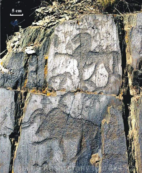
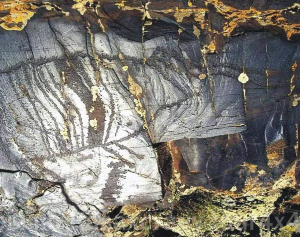 The repertoire of the petroglyphs of the archaic period is very poor and is represented mainly by figures of wild bulls or bison (?) of large and gigantic size (up to 2 m), executed in outline (Fig. 18). The drawings differ greatly in style. In the group of 50-60 ancient images of bulls with long or short horns, 8 different styles can be distinguished.
Morphological analysis, supplemented by observations of patina and technique, makes it possible to distinguish three types of outline drawings: schematic, plastic and geometric. The first is characteristic only of images of bison (?) of very large size; the second — of bison (?) or bulls; the third — mainly of bulls.
Schematic figures are characterized by enormous size, rough contours, triangular animal heads not filled with pecking, and the connection of the lines of the figures with cracks. There are very few of them, and evidently these are the most ancient images. About 10 engravings in the plastic and geometric styles have been counted, demonstrating several transitional steps from outline to bands, and then from bands to silhouettes. Five cases of stratigraphic superposition of archaic petroglyphs have been recorded, showing the overlapping of outline figures by banded ones, and of banded ones by silhouette ones. The transformation of the plastic and geometric styles proceeds step by step from bands to silhouette together with the growth of realism, plasticity and detail of the images; the result of this transformation is the formation of the prototype of the petroglyphs of the Middle Bronze Age of the Chu-Ili Mountains.
A special group of the most difficult-to-identify petroglyphs is formed by compositions with cup marks, images of people with arms outstretched to the sides, archers and goats. The compositions are formed by an elegant combination of all these images with cup-shaped depressions. The average size of the figures is from 10 to 20 cm. The linear manner of the drawings brings them close to the most ancient outline images of bulls and makes it possible to tentatively associate them with the culture of the Neolithic.
Middle Bronze period (15th (?) – 13th centuries BC). This period is the “golden age” of the Kulzhabasy petroglyphs. The epochs of the Middle and Late Bronze Age are seen together as the time of the highest activity in the creation of the petroglyphs of the monument; almost half of the drawings appeared at this time, and for the most part of the best quality. The petroglyphs of this period, like the more ancient ones, are concentrated in the main 6 valleys (mainly V3 and V4), but are also spread over some other valleys provided with water and suitable rock material (V11-14).
In the Middle Bronze period petroglyphs were carved both on the best horizontal and on vertical rock surfaces. The work was done with metal tools; the execution is of very high quality, with deep, regular, dense pecking. The average size of the figures is 20-30 cm.
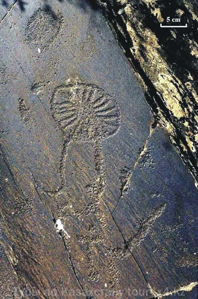 The repertoire and the execution are the most distinctive characteristics of the petroglyphs of this period. The repertoire becomes richer and numbers up to 20-25 principal subjects (Figs. 19-24). Wild bulls still remain the main theme, but many other images already appear: horses, goats, rams, deer, predators (wolf, cheetah, bear, lion), hare, stork, zoo- and ornithoanthropomorphic characters, etc. The images of man are diverse: a man, a woman, a man in a wolf mask, hunting, pairs of men with arms raised upward, duels and “meetings”. There are many images of wheels and chariots, solar signs, footprints, squares, labyrinths and symbols. Some compositions are repeated very often: processions of animals (mainly moving to the right), man and animals, hunter and prey, meetings of people, horned animals with solar signs.
The images of the Middle Bronze Age were created next to the petroglyphs of the archaic period and thus form diachronic compositions in which the different phases are determined by differences in patina and style. This manner of supplementing earlier compositions with small figures would become characteristic of the subsequent periods as well.
In style, the petroglyphs of the Middle Bronze Age show a tendency toward naturalism: realities and actions are conveyed by details of the silhouettes (4 legs, feet, knees, hair, sex features, faces); the three-dimensionality of the images is conveyed by means of layered lines; the plasticity of the bodies — by means of micro-relief and incomplete silhouettes. The stylistic differences based on these dichotomies are very significant, and in time individual authors may be distinguished. It is also possible to determine intermediate steps in the development of the style; some images of bulls seem to be transitional forms of the archaic period and are evidence of local development; the cup marks, which were used in the archaic period to denote the head, continue to be used as a syntactic element to convey feet, arms, heads and individual spots.
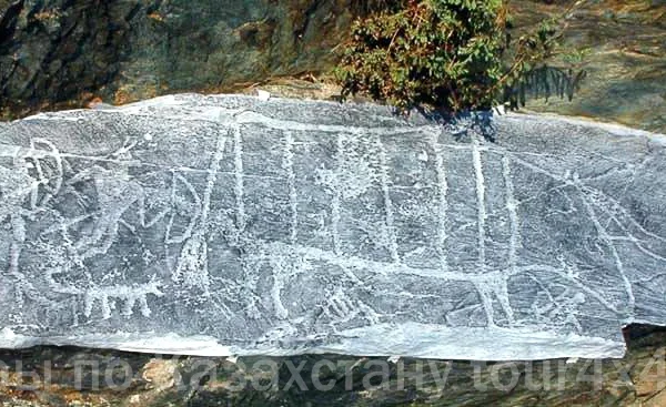 Late Bronze period (12th – 9th centuries BC). The petroglyphs of this period are a continuation of the petroglyphs of the Middle Bronze Age, so the boundary between them has not been established precisely.
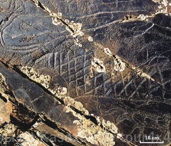
The engravings were executed in more or less the same quantity and in the same groups as in the preceding time, spreading further onto the peripheral rocks. They occupy vertical and small surfaces suitable for figures of smaller size (on average 15 cm) and finer lines. The effects of three-dimensionality and plasticity of the images become rarer, and the execution is of lower quality.
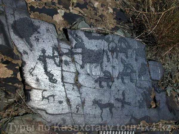
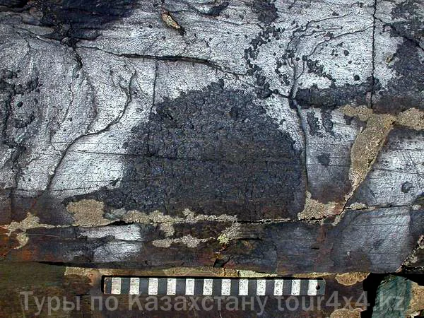 The repertoire changes somewhat with the addition of several subjects and images typical of this period: domestic animals, images of deer and snakes, bulls with elongated horns, horned horses, riders on horses, goats or camels, several types of wheels and chariots, etc. The relative frequency of the subjects changes: there are fewer images of bulls, while the number of images of goats, horses, dogs, riders, hunters and mirrors increases (Figs. 25, 26).
As in the preceding period, the engravings of the Late Bronze Age often surround the more ancient large-size petroglyphs in compositions without overlapping them. The styles have more analogies with other monuments of Chu-Ili and Karatau (but not with the eastern region of Semirechye, separated by the Ili River), testifying to a process of standardization alongside the general development of interaction.
Early Iron Age (Saka period, 8th-3rd centuries BC). The frequency of petroglyph creation declines by more than half; the drawings of this period make up approximately 20% of the entire complex. They are spread over all 14 valleys, but there are especially many of them in V2-6 and V12, where they are located predominantly apart from the early engravings.
The petroglyphs of this epoch are often pecked on vertical surfaces occupying a special, theatrical position, and sometimes also on horizontal ones with a convenient view. The drawings are usually executed very precisely, with great skill; the average size of the figures is 15 cm. The repertoire, as everywhere in this period in southern Kazakhstan, is sharply reduced to a few subjects: mostly goats, a few hunters and horsemen; the animals are depicted with standardized bodies in the spirally dynamic style (animal style). Goats, rams and deer become the principal images and will remain so until the end of petroglyph creation. The distinguishing of stylistic varieties and sub-stages will become possible after they have been identified in Semirechye as a whole, including some original local variants (V4).
Surprising is the appearance of a small series of compositions, among which three panels in V5 on group 1 stand out, with images of mirrors, warriors and a pregnant woman beside a cauldron (Fig. 7: 1-3). Equally unique are two series of signs resembling inscriptions in V4 and V5. These petroglyphs seem to be the creations of gifted masters.
In the manner of drawing, rounded dynamic forms predominate and the bends in the joints of the legs are emphasized; outline images with lines inside appear again. However, from the Saka period onward the local peculiarities of the styles are lost; their types can be found in the Chu-Ili Mountains, in southern Kazakhstan and further to Siberia and southern Central Asia. The process of homogenization characteristic of the Saka period signifies the emergence of a major cultural change connected with the irreversible growth of human interaction in the steppes of Central Asia.
The Saka petroglyphs, with the poverty of their repertoire, the spectacular quality of their visual placement and an execution similar to toreutics, indicate, on the one hand, a partial loss of significance of the places with petroglyphs, and on the other, the emergence of new symbolic needs, apparently connected with the appearance of aristocratic clans and tribes. The impoverishment of the repertoire and the decline in the significance of the petroglyphs are the two phenomena that become characteristic of the subsequent periods: the image of the ram will become the dominant motif, both for the petroglyphs and for the funerary rites.
Early Iron Age (Usun period, 2nd century BC – 5th century AD). The petroglyphs of this time are a poor appendage to the Saka creativity, with many losses and very few innovations, less careful execution and a simplification of the styles. The frequency of execution and the location within the complex are the same as in the Saka period. They are executed on vertical and horizontal rocks, even if these are of poor exposure, visibility and represent mediocre material. The size of the figures becomes smaller and on average does not exceed 10 cm; the execution of the drawings is of medium and low quality.
Compositions with meager semantic content. The use of early compositions with the addition of small figures of goats and rams again becomes a widespread technique, and this trend, which arose in the Late Bronze Age, will characterize the rock art of the Turkic period thereafter.
The repertoire is further reduced and limited to only a few images: goat, ram, horse, archer, horseman on horseback. The zoomorphic figures are static and apparently depict domestic animals.
The style is of the simplest execution: linear, poor in meaningful elements (two legs, one horn, joints and fleece not indicated, etc.) and, on the whole, very homogeneous. Some images of fairly high quality of execution are represented by figures of animals with heavy, voluminous, plastic bodies, executed very carefully with the technique of pecking and grinding.
On the whole, the petroglyphs of the Usun period, even with their poor repertoire, demonstrate a return to naturalism, as if after the Saka aristocratic manipulations with the expressiveness of the petroglyphs the inhabitants of the valleys had again returned to the independent depiction of the relatively simple events of everyday life. The horse acquires a high status as never before. The supplementation of compositions and the palimpsests, already common since the Late Bronze period, now become universally accepted, which is a sign of interest in such panels and in narratives from different times, as well as of the gradual reduction on the spot of good accessible material.
Medieval (Turkic) period (6th-14th centuries AD). This period shows in Kulzhabasy a further and final decline in the importance of petroglyphic activity alongside the introduction of several significant elements.
The creation of images in this period decreases sharply and amounts to less than 10% of the total number of petroglyphs. They are often located in some of the groups used in the Usun period, but are absent in V1, V5, V13. As in the preceding period, they are characterized by the same indifference to the quality of the rock surfaces and the same medium quality of execution. The figures are of small size; made with sharp metal tools; smoothly ground. For the most part the images are of low standard quality; high-quality execution is encountered extremely rarely, but a number of remarkable engravings are present in V2, V3, V14.
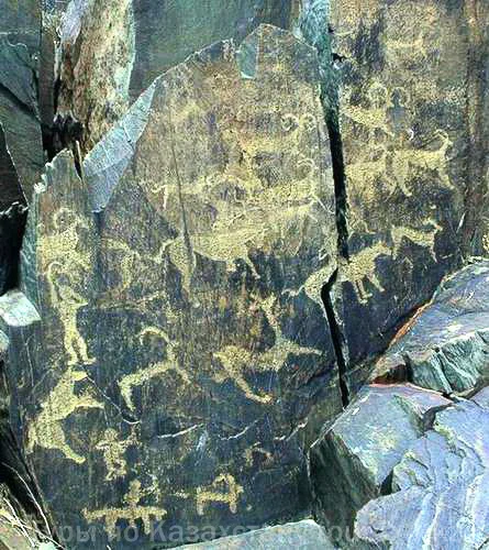 The repertoire increases somewhat owing to imitations of the Saka repertoire (the frequent presence of deer and horses). Some innovations were introduced, such as the leaping deer with frontally unfolded horns, but mainly there are images of warriors and horsemen, which are the best creations of this period (Fig. 27). The supplementation of ancient compositions and palimpsests become very widespread techniques.
The Turks spread their pastoral activity, their military control and the creation of petroglyphs to the most remote periphery of the complex. The petroglyphs seem to have been made only to attest to a human presence: the rock material does not matter, there is neither beauty of execution nor novelty of images (mostly these are animals and deer); the most significant petroglyphs are located near the paths. As in the Usun period, additions to early compositions and palimpsests are found in abundance. Alongside the evidence carved on the rocks of a rich pastoral society, images of warriors and horsemen are often encountered, demonstrating the spread in society of a military aesthetic and political symbolism.
With the establishment of the military ideological dominance of the Turks, the development of writing and the spread of Islam, the communicative significance of the petroglyphs is lost, and the petroglyphs of the Kulzhabasy complex lose their importance.
The petroglyphs of the Turkic period apparently represent the last period of petroglyph creation of the Kulzhabasy complex. Petroglyphs that could be attributed to the ethnographic period have not been found here. Kazakh petroglyphs may be found in the Kostobe Mountains on the western periphery of the complex; Dzungarian (Kalmyk) inscriptions have been discovered 30 km from the eastern end of the ridge.
formation of the complex, cultural context
(R. Sala)